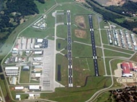
FAA INFORMATION EFFECTIVE 17 DECEMBER 2009
Location
| FAA Identifier: |
RVS |
| Lat/Long: |
36-02-22.6000N / 095-59-04.7000W 36-02.376667N / 095-59.078333W 36.0396111 / -95.9846389 (estimated) |
| Elevation: |
638 ft. / 194.5 m (surveyed) |
| Variation: |
06E (1985) |
| From city: |
5 miles S of TULSA, OK |
| Time zone: |
UTC -6 (UTC -5 during Daylight Saving Time) |
| Zip code: |
74132 |
Airport Operations
| Airport use: |
Open to the public |
| Activation date: |
07/1958 |
| Sectional chart: |
KANSAS CITY |
| Control tower: |
yes |
| ARTCC: |
KANSAS CITY CENTER |
| FSS: |
MC ALESTER FLIGHT SERVICE STATION |
| NOTAMs facility: |
RVS (NOTAM-D service available) |
| Attendance: |
0600 - 2200 AFT HRS BY PRIOR ARRANGMENT. |
| Pattern altitude: |
1713 ft. MSL |
| Wind indicator: |
lighted |
| Segmented circle: |
yes |
| Lights: |
DUSK-DAWN WHEN ATCT CLSD HIRL RY 01L/19R PRESET MED INTST; TO INCR INTST ACTVT - 120.3; MIRL RYS 13/31 & 01R/19L PRESET MED ONLY. |
| Beacon: |
white-green (lighted land airport) |
Airport Communications
| CTAF: |
120.3 |
| UNICOM: |
122.95 |
| ATIS: |
126.5 |
| WX ASOS: |
PHONE 918-299-0740 |
| RIVERSIDE GROUND: |
121.7 [0700-2200] |
| RIVERSIDE TOWER: |
119.2 120.3 [0700-2200] |
| TULSA APPROACH: |
119.85(356-174) 134.7(175-355) |
| TULSA DEPARTURE: |
119.85(356-174) 134.7(175-355) |
| CLEARANCE DELIVERY: |
124.5 |
| PRE-TAXI CLEARANCE: |
124.5 |
| BASIC RADAR SVC: |
134.7(175-355) |
| BASIC RADAR SVC IC: |
119.85(356-174) |
| WX ASOS at TUL (11 nm NE): |
PHONE 918-838-8437 |
| WX AWOS-3 at OWP (11 nm NW): |
118.325 (918-246-2635) |
- FREQ 119.2 USED AS LCL/P ONLY WHEN ADVERTISED ON ATIS.
Nearby radio navigation aids
| VOR radial/distance |
|
VOR name |
|
Freq |
|
Var |
| GNPr348/7.2 |
|
GLENPOOL VOR/DME |
|
110.60 |
|
06E |
| TULr217/13.4 |
|
TULSA VORTAC |
|
114.40 |
|
08E |
| OKMr336/21.6 |
|
OKMULGEE VOR/DME |
|
114.90 |
|
08E |
| NDB name |
|
Hdg/Dist |
|
Freq |
|
Var |
|
ID |
| WILLIAM POGUE |
|
128/11.5 |
|
362 |
|
06E |
|
OWP |
--- .-- .--. |
| HENRYETTA |
|
358/38.1 |
|
267 |
|
04E |
|
HET |
.... . - |
| CUSHING |
|
072/39.4 |
|
242 |
|
05E |
|
CUH |
-.-. ..- .... |
Airport Services
| Fuel available: |
100LL JET-A FUEL AVBL 24 HRS WITH CREDIT CARD. |
| Parking: |
hangars and tiedowns |
| Airframe service: |
MAJOR |
| Powerplant service: |
MAJOR |
| Bottled oxygen: |
LOW |
| Bulk oxygen: |
NONE |
Runway Information
Runway 1L/19R
| Dimensions: |
5102 x 100 ft. / 1555 x 30 m |
| Surface: |
asphalt, in fair condition |
| Weight bearing capacity: |
| Single wheel: |
30.0 |
| Double wheel: |
60.0 |
|
| Runway edge lights: |
high intensity |
|
RUNWAY 1L |
|
RUNWAY 19R |
| Latitude: |
36-01.980645N |
|
36-02.798760N |
| Longitude: |
095-59.272350W |
|
095-59.033508W |
| Elevation: |
621.5 ft. |
|
637.9 ft. |
| Gradient: |
0.3% UP |
|
0.1% |
| Traffic pattern: |
left |
|
right |
| Runway heading: |
007 magnetic, 013 true |
|
187 magnetic, 193 true |
| Markings: |
precision, in fair condition |
|
nonprecision, in fair condition |
| Visual slope indicator: |
4-light PAPI on left (3.00 degrees glide path) |
|
4-light PAPI on left (3.20 degrees glide path) |
| Runway end identifier lights: |
no |
|
|
| Touchdown point: |
yes, no lights |
|
yes, no lights |
| Instrument approach: |
ILS |
|
|
| Obstructions: |
none |
|
42 ft. trees, 1125 ft. from runway, 22:1 slope to clear |
Runway 1R/19L
| Dimensions: |
4208 x 100 ft. / 1283 x 30 m |
| Surface: |
asphalt, in good condition |
| Weight bearing capacity: |
| Single wheel: |
30.0 |
| Double wheel: |
60.0 |
|
| Runway edge lights: |
medium intensity |
|
RUNWAY 1R |
|
RUNWAY 19L |
| Latitude: |
36-02.041147N |
|
36-02.715892N |
| Longitude: |
095-59.108682W |
|
095-58.911658W |
| Elevation: |
619.0 ft. |
|
630.0 ft. |
| Gradient: |
0.3% |
|
0.1% |
| Traffic pattern: |
right |
|
left |
| Runway heading: |
007 magnetic, 013 true |
|
187 magnetic, 193 true |
| Displaced threshold: |
no |
|
142 ft. |
| Markings: |
nonprecision, in good condition |
|
nonprecision, in good condition |
| Visual slope indicator: |
2-box VASI on left (3.00 degrees glide path) |
|
2-box VASI on left (3.00 degrees glide path) |
| Runway end identifier lights: |
|
|
no |
| Touchdown point: |
yes, no lights |
|
yes, no lights |
| Obstructions: |
none |
|
8 ft. road, 200 ft. from runway APCH RATIO 43:1 FM DSPLCD THLD. |
Runway 13/31
| Dimensions: |
2641 x 50 ft. / 805 x 15 m |
| Surface: |
asphalt, in fair condition |
| Weight bearing capacity: |
|
| Runway edge lights: |
medium intensity |
| Runway edge markings: |
RY MARKINGS OBSCURRED. |
|
RUNWAY 13 |
|
RUNWAY 31 |
| Latitude: |
36-02.489660N |
|
36-02.192553N |
| Longitude: |
095-59.226792W |
|
095-58.835112W |
| Elevation: |
623.8 ft. |
|
614.6 ft. |
| Gradient: |
0.1% |
|
0.3% |
| Traffic pattern: |
left |
|
right |
| Runway heading: |
127 magnetic, 133 true |
|
307 magnetic, 313 true |
| Markings: |
basic, in fair condition |
|
basic, in fair condition |
| Visual slope indicator: |
2-box VASI on left (4.00 degrees glide path) |
|
2-box VASI on left (3.00 degrees glide path) |
| Obstructions: |
67 ft. trees, 1391 ft. from runway, 17:1 slope to clear |
|
63 ft. trees, 1818 ft. from runway, 25:1 slope to clear |
Airport Ownership and Management from official FAA records
| Ownership: |
Publicly-owned |
| Owner: |
CITY OF TULSA TULSA ARPT AUTHORITY BOX 581838 TULSA, OK 74158 Phone 918-838-5000 |
| Manager: |
STEVEN MUSHRUSH 8303 S. HANGAR RD. TULSA, OK 74132 Phone 918-299-5886 |
Airport Operational Statistics
| Aircraft based on the field: |
|
297 |
| Single engine airplanes: |
|
237 |
| Multi engine airplanes: |
|
33 |
| Jet airplanes: |
|
19 |
| Helicopters: |
|
8 |
|
|
 |
|
| Aircraft operations: avg 929/day * |
| 60% |
local general aviation |
| 40% |
transient general aviation |
| <1% |
air taxi |
| <1% |
military |
| * for 12-month period ending 22 September 2008 |
|
Additional Remarks
| - |
THE NE, NW & SW RAMPS AND PORTIONS OF TWYS C, D, & G ARE NOT VISIBLE FM ATCT. |
| - |
NOISE ABATEMENT: NO TURNS ON DEPARTURE PRIOR TO 1500' MSL. |
| - |
NUMEROUS BIRDS ON & INVOF ARPT. |
Instrument Procedures
| STARs - Standard Terminal Arrivals |
| VINTA TWO |
|
|
IAPs - Instrument Approach Procedures |
| ILS OR LOC RWY 01L **CHANGED** |
|
|
| RNAV (GPS) RWY 01L |
|
|
| VOR/DME-A |
|
|
| VOR RWY 01L |
|
|
| NOTE: Special Alternate Minimums apply |
|
|
Departure Procedures |
| TULSA FIVE **CHANGED** |
|
|
| NOTE: Special Take-Off Minimums/Departure Procedures apply |
|
|
Other nearby airports with instrument procedures:
KTUL - Tulsa International Airport (11 nm NE) KOWP - William R. Pogue Municipal Airport (11 nm NW) KOKM - Okmulgee Regional Airport (22 nm S) 3F7 - Jones Memorial Airport (25 nm SW) KGCM - Claremore Regional Airport (29 nm NE)
|
|